‘Tripe Threat,’ ‘Life-Threatening’ Winter Storms To Hammer U.S. This Week
[spacer size=”10″]
According to ABC News, more than half the country will begin receiving snow this week.
ABC News is calling the storm a “triple-threat of winter weather.”
Here’s a quick rundown of what’s expected to come:
-8 inches of snow is predicted on the East Coast, beginning today, from Washington, D.C. to Boston.
-Philadelphia to New York will see rain turning over to snow today. 5-8 inches of snow is predicted.
-On Tuesday, 5-10 inches of snow will likely blanket Colorado to Iowa. The storm will then move on to hammer the East Coast. “this time heaviest snow will be inland in the Northeast with rain, sleet and snow along the coast from Washington, D.C., to Boston,” ABC News stated.
-Near the end of the week, a third winter storm is expected to hit.
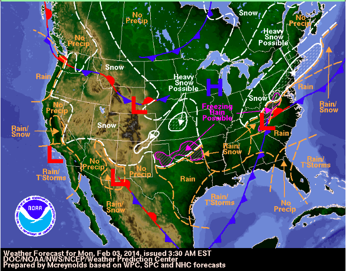
From NOAA:
3-Day Forecast
Monday:
-Heavy rain in the Northern Mid-Atlantic
-Sleet, freezing rain or snow expected in parts of the Tennessee Valley.
-15 to 30 degrees below average in the Northern High Plains.
-Moderate snow over the Northern Mid-Atlantic which will move into the southern New England states.
-Moderate to heavy rail will blanket the Southern Mid-Atlantic and Central/South Appalachians.
-Pockets of freezing rain will develop in the Tennessee Valley.
-Snow will blanket parts of the Rockies and Northern High Plains
-Parts of the Pacific Northwest Coast will see coastal rains.

Tuesday:
-A winter Strom will develop over the West and Central Gulf Coast. The storm will then move northeast.
-A winter storm will will move into the Tennessee Valley by Tuesday evening.
-The winter Storm/moderate will move into the Ohio Valley.
-Showers and thunderstorms will hit the Central Gulf coast on Tuesday morning.
-Moderate to heavy snow/rain will fall from the Ohio Valley to the Northern Mid-Atlantic Tuesday evening.
-Freezing rain and sleet is expected in the southeast portion of the Middle Mississippi Valley.
-Snow is expected in the Central Rockies and other parts of the Central and Southern Plains.
-Rain will develop over parts of the Southern Plains on Tuesday morning.
-Freezing rain is likely to hit parts of Southeastern Oklahoma.
Talk about gloom and doom! A meteorologist in Michigan is predicting snowmageddon for West Michigan.
According to Grand Rapids Fox 17, wind chills are expected to reach 30 degrees below zero and up to 20 inches of snow is being forecasted, “creating a potentially life-threatening forecast for parts of West Michigan early next week.”
The National Weather Service is predicting heavy snowfall beginning Monday.
SAULT STE. MARIE…PARADISE…TAHQUAMENON FALLS AND ENGADINE- SNOW DEPTH……….24 TO 36 INCHES.
ST. IGNACE…RUDYARD…KINCHLOE AND DETOUR VILLAGE-SNOW DEPTH……….20 TO 27 INCHES.
PETOSKEY…GAYLORD…CHARLEVOIX…GRAYLING…MANCELONA…BOYNE CITY AND KALKASKA-SNOW DEPTH……….18 TO 35 INCHES.
TRAVERSE CITY…CADILLAC…FRANKFORT…EMPIRE…LAKE CITY AND MANISTEE-SNOW DEPTH……….19 TO 32 INCHES.
ALPENA…CHEBOYGAN…ROGERS CITY…HILLMAN…INDIAN RIVER AND ATLANTA-SNOW DEPTH……….15 TO 26 INCHES.
MIO…HARRISVILLE…HOUGHTON LAKE…TAWAS CITY…WEST BRANCH AND STANDISH-SNOW DEPTH……….15 TO 21 INCHES.
Source:
Fox 17
NOAA
Weather Channel
ABC News