Winter storm to cause ‘widespread hazardous travel’ this week

The National Weather Service (NWS) is warning drivers to plan ahead for a large scale winter storm expected to impact travel in a large portion of the U.S. this week.
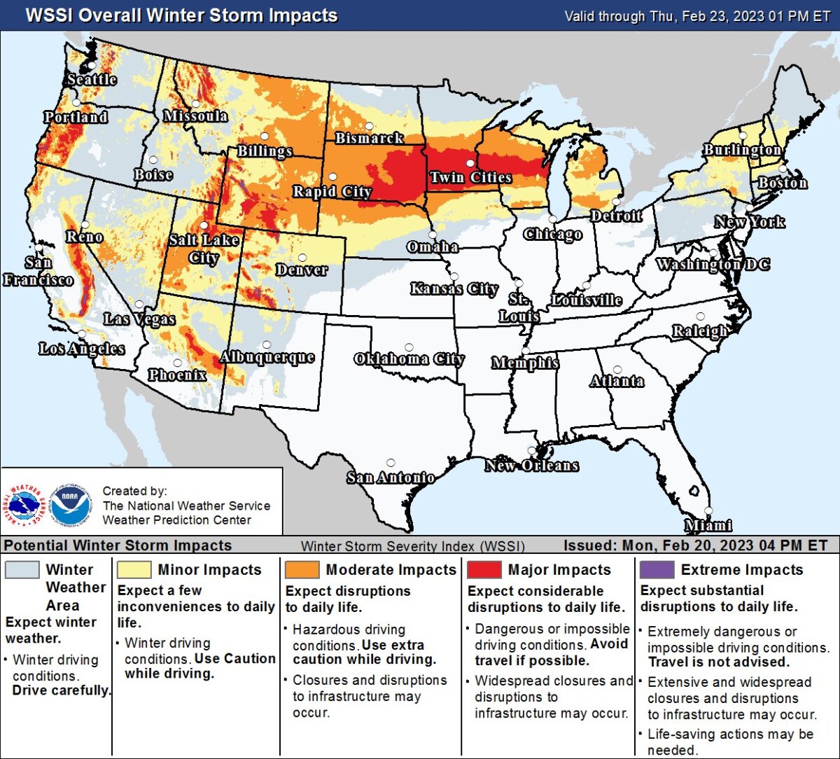
The NWS has issued an alert for “Widespread Hazardous Travel from the West to the Great Lakes” expected to last through through Friday.
From the NWS travel alert:
Several weather systems will stretch impacts from Coast to Coast. Heavy snow to low elevations in the West will extend across the Intermountain West to the Great Lakes. Strong winds will extend across the West and Southwest with critical fire weather threats in the South High Plains. Strong thunderstorms and damaging winds in the Mid-Atlantic.
Snowfall amounts of one to two feet are expected for most of the mountain ranges across the West, with higher amounts possible in some areas.
Heavy snow is also expected in the Northern Plains and Upper Midwest as the week continues.
From the NWS:
An axis of heavy snow will also expand eastward across the Northern Plains and into the Upper Midwest/Great Lakes and Interior Northeast/New England Tuesday-Wednesday as a strong low pressure system organizes in the lee of the Rockies and moves northeastward across the Plains/Midwest. Some locations across the Upper Midwest/Great Lakes will have only a very brief reprieve from a clipper system exiting the region before this next round of heavy snow moves in. There is a high probability of snow totals over 8″ front South Dakota eastward through southern Minnesota, northern Wisconsin, and the Upper Peninsula/northern Lower Peninsula of Michigan. Locally higher totals of 1-2 feet are possible, particularly across southern Minnesota. Heavy snow rates of 1-2″ per hour and gusty winds producing areas of blowing snow will lead to treacherous, potentailly impossible travel conditions and possible power outages. Heavier snow totals of 8-12″ are also likely for higher elevations in the Interior Northeast including the Adirondacks and the Green and White Mountains, with lighter accumulations of around 2-4 inches at lower elevations across Upstate New York and central New England. A heavy wintry mix of snow, sleet, and freezing rain is expected along the southern end of the snow axis across the Upper Mississippi Valley and into the Lower Great Lakes. Ice accumulations of 0.1-0.25″, locally higher, are possible.
Additionally, in the West and High Plains, “very strong, gusty winds of 50-60 mph, locally as high as 80 mph” are expected on Tuesday and Wednesday.
Thunderstorms and possible flooding are also predicted across the Midwest and Plains late Tuesday night into Wednesday.
Follow the U.S. National Weather Service for the latest updates on the winter storm.